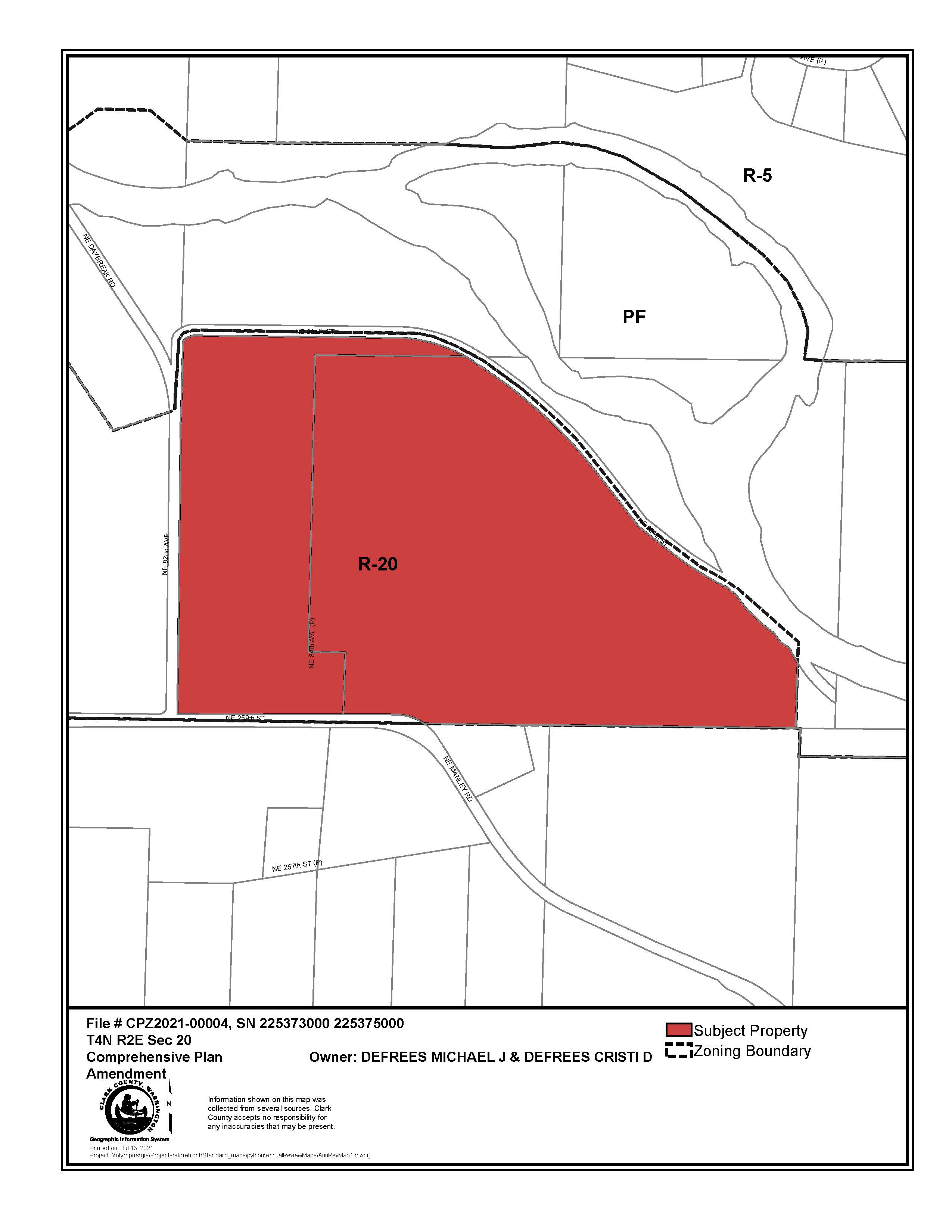
Defrees Annual Review
Project Summary
The applicant is requesting to amend the comprehensive plan and zoning map designation from Rural 20 (R-20) to Rural 5 (R-5) on two parcels that total 51.91 acres (225373000 and 225375000).
Background
The applicant owns two parcels (225373000 and 225375000) that are designated Rural 20 (R-20) and are located at 26002 NE 84th Ave., Battle Ground, WA 98604 and 8408 NE 259th St., Battle Ground, WA 98604, at the intersection of NE 82nd Ave. and NE 259th St. The subject parcels are approximately 1.25 miles Northwest of the Battle Ground city limits.
On parcel 225373000 there is a single-family home, detached garage, manufactured home, and outbuilding. On parcel 225375000, there is a mobile home and three outbuildings. All buildings on both sites are clustered together near a private road, NE 84th Ave, with site access off NE 259th St. The remainder of the subject parcels are primarily flat, grassy fields, with additional vegetation near an on-site stream.
There is a home business on the property for excavation, heavy equipment, and general contracting, which several of the outbuildings are used for. The majority of the subject site land is farmed for hay.
A small tributary of the East Fork Lewis River runs across parcel 225375000, roughly south to north. The tributary also crosses over a sliver of parcel 225373000. The tributary is a stream that falls under the Shoreline Management Act and has a Rural Conservancy Residential designation. The parcels include areas with flood hazard areas (100-year floodplain) and riparian habitat. Much more of parcel 225375000 (the eastern parcel) is encumbered than parcel 225373000 (the western parcel).
Clark County owns the properties to the north, east, and west of the subject parcels. Daybreak Regional Park and Boat Launch is immediately to the north. The property immediately to the west of the subject parcels is in the Legacy Lands Program. The East Fork Lewis River abuts the easternmost parcel towards its SE corner. To the south of the subject parcel is private property with Rural 5 zoning.
Comprehensive plan and zoning designations immediately surrounding the subject parcel are Public Facility to the north and east, R-20 to the west, and R-5 to the south.
The applicant is requesting to amend the comprehensive plan designation and zoning from Rural 20 (R-20) to Rural 5 (R-5) on two parcels (225373000 and 225375000). The subject parcels total 51.91 acres per the county Assessor’s GIS data. If rezoned to R-5, the site could potentially be subdivided into 10 lots, 8 more than the current R-20 zoning allows.
Both Rural-20 and Rural-5 zoning are “intended to provide lands for residential living in the rural area. Natural resource activities such as farming and forestry are allowed and encouraged in conjunction with the residential uses in the area. These areas are subject to normal and accepted forestry and farming practices.” [CCC 40.210.020]. Residential uses are emphasized to a greater extent with the Rural-5 designation, whereas a Rural 20 designation “applies to rural areas where the lands act as a buffer to Natural Resource designated lands, are used for small scale forest or farm production or contain significant environmentally constrained areas as defined by applicable county code and related regulations” [2016 Comprehensive Plan, page 36].
Public Meetings
Meeting information and project materials will be posted here.
County Council Meetings
March 1, 2022 County Council Hearing at 10 a.m., via Webex and CVTV live streaming.
- Planning Commission Recommendation
- Maps
- Transportation Impact Analysis
- Planning Commission Minutes 11/18/2021
- Public Comments
- Applicant Submittal
- Additional Applicant Information (1/18/2022)
- Additional Applicant Information (2/22/2022)
- SEPA
- Supporting Documents
- Interactive Map
- Presentation
Jan. 19, 2022 County Council Work Session at 9 a.m., via Webex.
Planning Commission Meetings
November 18, 2021 at 6:30 p.m., Planning Commission hearing via Webex with CVTV live streaming - Please visit the Planning Commission meeting page for info on how to participate in the hearing.
- Planning Commission Minutes
- PC Recommendation
- Staff Report
- Maps
- Transportation Impact Analysis
- Applicant Submittal
- SEPA
- Supporting documents
- Interactive map
- Public Comments Received
- Power Point Presentation
November 4, 2021 at 5:30 p.m., Planning Commission work session via Webex - Please visit the Planning Commission meeting page for info on how to listen to the work session.
